Geography Class 40
A BRIEF OVERVIEW OF THE CLASS (05:12 PM)
MODERN THEORY OF MONSOON (05:24 PM)
- Winter season (November- February)
- Low temperature and high-pressure conditions are prevailing over the northern plains.
- It causes Anti-cyclonic circulations causing winds to blow outward from the land over which air is subsiding.
- The sky is clear and dry.
- The subtropical westerly Jetstream is strong and well-established. It is bifurcated into two branches i.e. towards the north and south of the Tibetan plateau. This southern branch is stronger and is well-established over the northern Ganga plains.
- This intensifies surface Anti-cyclones and causes winds to blow from land to sea in a North-east direction.
- North-east winds after crossing the Bay of Bengal pick up moisture and causes precipitation along the Coromandel coast.
- Spring season (March-May)
- The temperature has started to rise and pressure is falling
- The weather is extremely hot and dry
- The subtropical westerly Jet stream begins to weaken and the southern Branch eventually moves entirely to the North of the Tibetan Plateau
- This triggers convection and precipitation in some regions. They are called Pre-monsoon showers.
- Mango showers in Kerala- It helps in the ripening of mangoes
- Blossom showers in Karnataka- It helps in coffee flowering
- Norwesters or Kal Baishaki. In Assam, it is called as Bardoli Chheerha. It helps in Jute and rice cultivation
- Loo in northern plains from Punjab to Bihar.
- Summer season (May-August) (06:26 PM)
- The weather is extremely hot and dry. High temperature causes the complete development of low-pressure cells over deserts and the Northern Plains
- ITCZ gradually shifts toward the North and attracts the southern trade winds toward the north of the equator.
- These southern Trade winds after crossing the equator turn right under the influence of Coriolis force and starts to blow as southwest Monsoon winds.
- Temperature stratification in the air will not allow large-scale convection preventing major storms.
- The tropical easterly jetstreams and depressions in the Bay of Bengal help in disturbing the stratified air and triggers large-scale precipitation.
- The tropical easterly Jet stream is a low-level Jet stream existing over South Asia and Africa in Summer. It causes a change of divergence to convergence on the surface.
- The sudden onset of moisture-laden winds associated with violent Thunder and lightning is called as Bursting of the Monsoon.
- The Somali jetstream is a local jetstream off the coast of East Africa. It strengthens High pressure near Madagascar. The High-pressure cell causes a faster flow of winds toward India.
- In some regions due to local stability conditions, temperature stratification reappears or the wind starts blowing parallel to the Topography resulting in Break in the Monsoon.

- Autumn season (September- October)
- ITCZ or Monsoon trough starts to move back gradually towards the south.
- This also brings back the maximum extent up to which southwest winds blow which is called the retreat of Monsoon.
- The southwest winds slowly get replaced by North-east winds.
- The high temperature with dry conditions existing over the Northern plains during October is called October Heat.
- The subtropical westerly Jet streams reappear to the south of the Tibetan Plateau creating dry conditions.
CHARACTERISTICS OF INDIAN MONSOON (07:08 PM)
- The onset of monsoon is gradual and withdrawal is more gradual.
- As the wind moves from sea to land, the amount of precipitation gradually decreases.
- The duration of the monsoon also decreases from sea to land.
- Temporal variation- Variation of rainfall with time.
- Spatial variation- Variation of rainfall from one location to another.
- Distribution of Monsoon rainfall
- The monsoon winds get divided into two branches- The Arabian Sea branch and the Bay of Bengal branch
- Bay of Bengal Branch
- It moves parallel to the Coromandel coast and causes no precipitation. From the K-G delta, rainfall starts to increase towards West Bengal.
- Along the Ganga delta, the Bay of Bengal branch is divided into eastern and western by Himalayan Foothills.
- The Eastern branch hits Meghalaya Plateau perpendicularly causing very heavy precipitation.
- The Western Branch moves across the Ganga plains.
- The precipitation decreases from east to west along the Ganga plains
- Precipitation increases towards the Himalayas from South to North.
- Arabian Sea Branch
- It hits the Western Ghat at the right angle causing heavy precipitation along the western side.
- Along the Eastern side, the descending winds result in a rainshadow effect creating dry conditions in Maharashtra and Karnataka.
- The Arabian Sea Branch advances towards Gujarat and blows parallel to Aravallis resulting in very less precipitation in Rajasthan.
- The Arabian Sea Branch meets the Bay of Bengal Branch near Agra and the combined branch causes precipitation in the regions to the North.
WESTERN DISTURBANCES (07:46 PM)
- Western Disturbance is active between November to April.
- During winters Northern India experiences cold and dry conditions along with strong westerly Jet streams.
- Mediterranean region receives rainfall due to onshore westerlies and temperate cyclones.
- The subtropical westerly Jetstreams along the Mediterranean region pick up the moisture content and low-pressure disturbance and are brought to India.
- When these winds accumulate near North-western Himalayas it causes precipitation.
- The precipitation due to western disturbance decreases from west to east along the Ganga plains
- Significance of Western disturbances
- It causes an abrupt decrease in temperature and snowfall along the northern hills
- It may result in cloudbursts and flash floods. example- 2010 Leh Cloudburst
- It is good for winter crops of wheat and mustard.
- Impact of El-Nino, La-Nina, Indian Ocean Dipole, and Maden Julian Oscillation on Indian Monsoon.
- Refer to oceanography.
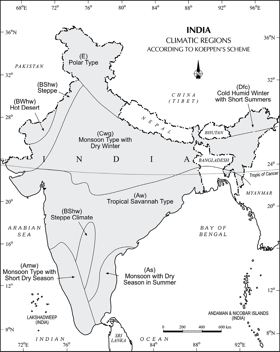
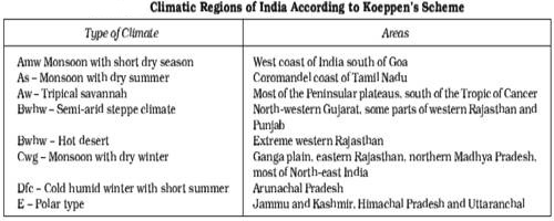
CLIMATIC REGIONS OF INDIA (08:04 PM)
- Refer to PPT in the class
The topic for the next class:- Soils.